
City
Cape Town
Capital of South Africa
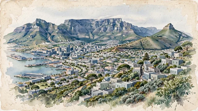
What guided this image
- Landmarks
- Table Mountain's; Devil's Peak; City Bowl; Signal Hill; V&A Waterfront; Cape Dutch
- Viewpoint
- Favor a slightly elevated viewpoint from the lower slopes of Signal Hill, looking south across the City Bowl toward Table Mountain, with Devil's Peak to the left and Lion's Head rising to the right.
- Palette
- Green should be the predominant color, especially in the fynbos and pines on the mountain slopes, the leafy residential areas, and the overall visual impression.
- Guarded against
- Avoid making Cape Town look like Rio de Janeiro, Hong Kong, or a Mediterranean resort, and avoid Alpine character.
Population4,772,846Wikidata: 433,688
Coordinates33.93°S, 18.42°E
Elevation5 m
Area2,455 km²
Time zoneAfrica/JohannesburgUTC+2
Solar noon12:46clock runs 0.8 h ahead of the sun
Through the Earth
Dig straight through the Earth from Cape Town and you surface in open ocean, nearest to Princeville, United States — 1,318 km from the exact antipodal point.
Nearest cities in the atlas
| Gqeberha | ZA | 663 km |
| Bloemfontein | ZA | 911 km |
| Maseru | LS | 999 km |
| Soweto | ZA | 1,244 km |
| Gaborone | BW | 1,261 km |
| Johannesburg | ZA | 1,262 km |
| Windhoek | NA | 1,271 km |
| Durban | ZA | 1,272 km |
Twinned cities
- Buenos Aires AR
- Hangzhou CN
- İzmir TR
- Johannesburg ZA
- Monterrey MX
- Pune IN
- Saint Petersburg RU
7 of 13 twinned cities are in this atlas. See the full network →
This city sits on
- South Africacountry
- 34Sparallel
- UTC+2offset