
City
Montevideo
Capital of Uruguay
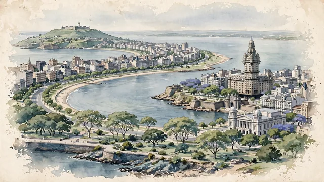
What guided this image
- Landmarks
- Art Deco; Gateway of the Citadel; Solís Theatre; Rambla; Río de la Plata; Cerro de Montevideo; French and Italianate; Belle Époque
- Viewpoint
- Favor an elevated coastal viewpoint looking along the curve of the Rambla toward the Ciudad Vieja peninsula, showing the sweeping waterfront, with the tower of Palacio Salvo anchoring the urban middle-ground and the distant Cerro de Montevideo across the bay.
- Palette
- Green should be the predominant color, especially in the tree canopies of Parque Rodó, the plazas, and the coastal gardens.
- Guarded against
- Avoid making Montevideo look like Rio de Janeiro (no tropical mountains) or Buenos Aires (Montevideo is much more coastal, relaxed, and defined by its Rambla and low hills).
Population1,270,737Wikidata: 33,994
Coordinates34.90°S, 56.19°W
Elevation41 m
Area730 km²
Time zoneAmerica/MontevideoUTC−3
Solar noon12:45clock runs 0.7 h ahead of the sun
Through the Earth
Dig straight through the Earth from Montevideo and you surface nearest to Sinan, South Korea — 210 km from the exact antipodal point.
Nearest cities in the atlas
| Buenos Aires | AR | 203 km |
| Porto Alegre | BR | 714 km |
| Córdoba | AR | 839 km |
| Asunción | PY | 1,078 km |
| Curitiba | BR | 1,245 km |
| Santiago | CL | 1,339 km |
| São Paulo | BR | 1,564 km |
| Guarulhos | BR | 1,578 km |
Twinned cities
- Barcelona ES
- Brasília BR
- Buenos Aires AR
- Caracas VE
- Curitiba BR
- Daejeon KR
- La Paz BO
- Lisbon PT
- Madrid ES
- Mexico City MX
- Quito EC
- Saint Petersburg RU
- Santo Domingo DO
- São Paulo BR
- Ulsan KR
15 of 26 twinned cities are in this atlas. See the full network →