
City
Khartoum
Capital of Sudan
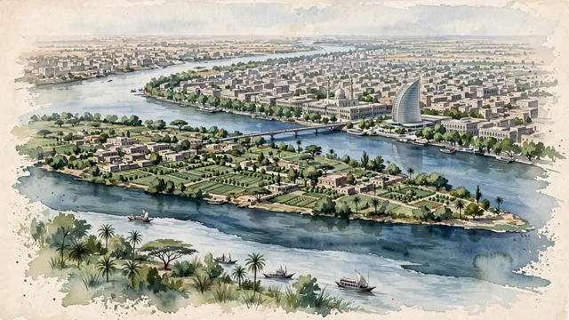
What guided this image
- Landmarks
- Blue Nile and White Nile; Tuti Island; Corinthia Hotel; Sudanese; Grand Mosque of Khartoum; Nile Street; Nile Street
- Viewpoint
- Favor a slightly elevated viewpoint overlooking the Nile confluence at Al Mogran, looking northeast across Tuti Island and the Blue Nile toward the riverfront of central Khartoum, capturing the meeting of the two rivers and the green belt along the banks.
- Palette
- Green should be the predominant color, especially in the irrigated farms of Tuti Island, the riverbank vegetation, neem and acacia trees, and public gardens along the Nile.
- Guarded against
- Avoid making Khartoum look like Cairo (no ancient Egyptian pyramids or massive medieval Cairo stone walls), Dubai (no towering glass skyscraper canyons), or Marrakech (no red-clay riads).
Population1,974,647Wikidata: 6,527,500
Coordinates15.55°N, 32.53°E
Elevation382 m
Area30,000 km²
Time zoneAfrica/KhartoumUTC+2
Solar noon11:50clock runs 0.2 h behind the sun
Through the Earth
Dig straight through the Earth from Khartoum and you surface nearest to Avatoru, French Polynesia — 72 km from the exact antipodal point.
Nearest cities in the atlas
| Khartoum North | SD | 11 km |
| Omdurman | SD | 11 km |
| Asmara | ER | 686 km |
| Jeddah | SA | 964 km |
| Addis Ababa | ET | 992 km |
| Makkah | SA | 1,010 km |
| Juba | SS | 1,194 km |
| Djibouti | DJ | 1,229 km |
Twinned cities
- Addis Ababa ET
- Amman JO
- Ankara TR
- Asmara ER
- Brasília BR
- Cairo EG
- Djibouti DJ
- Dubai AE
- Istanbul TR
- Saint Petersburg RU
- Tehran IR
- Wuhan CN
12 of 13 twinned cities are in this atlas. See the full network →